|
 The
Kidderminster Killer Audax - Saturday 21st July 2018 The
Kidderminster Killer Audax - Saturday 21st July 2018
|
Distance:
|
211km
|
 |
|
Climbing:
|
3750m
|
|
AAA Points:
|
3.75
|
|
Start / Finish:
|
Belbroughton, near Kidderminster
|
|
Controls:
|
-Acton Scott Farm Tea Room -Montgomery (open control
with cafes available)
-Ludlow
|
|
Average overall speed required:
|
14.3 - 30kph
|
This event is regarded as a classic in audax circles and
for justifiable reasons.
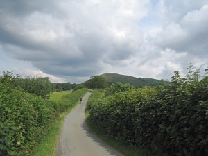
The Kidderminster Killer provides a challenging
ride through scenic and rural countryside. It often changes
character from rolling pastoral landscape to the starker heather
clad fells of the Long Mynd. In places, some of the gradients
are quite challenging but riders are soon rewarded with distant
views. Controls are located at Acton Scott Farm, Montgomery
and Ludlow where good quality cafes can be used for replenishment.
The 2016 route was revised to include a traverse
around the side of Clee Hills and over Clowes Top, meaning
fewer busy roads. The overall amount of ascent remains the
same.
Blog
posts and images by previous participants will give an impression
of the event :
Blog
by Lucy Sturgess
Lucy
Buchanan Parker & Alberto Contreras Sanz
Images
by Ian Taylor
Things to
be aware of:
- Remember your lights.
It is easy to underestimate your journey time on this route.
Dusk is at 9:15pm
- The route uses
a number of narrow lanes that may be covered by gravel.
- Ensure that your
brake blocks have plenty of tread. Some sections require
extreme caution on descents.
- There is no rescue
back-up but there are a number of rail stations near the
route in case you need to opt-out.
- Some climbs are
graded at 20% for short sections. Compact or triple chainrings
should suffice.
- Not all of the
control points are staffed but provision for obtaining Brevet
Cards, ATM or till receipts will be available.
- Remember a pen
for writing down answers to the information control questions.
Final
route sheets and GPX files will be e-mailed to entrants prior
to the event
2017 GPXs:
Stage 1
Stage 2
Stage 3
Stage 4
GPS are qwerky bits of kit and sometimes the GPX downloads
may interpret the files differently onto your machine. Also:
- Please note that you will need to monitor your distance
in order not to over-shoot any information control. Failure
to provide an answer to an information control question may
invalidate your audax attempt.
- View the route sheet to note any important hazard information.
Please note the GPS files have been generated with maximum
definition for profiling purposes. And as such probably has
too many track points for most GPS units, it is a relatively
simple task to reduce this to a number suitable for your unit.
First of all, save the file attached to your hard drive. And
once on the create route page, upload the file. Once uploaded,
click on the options box, and enter the number of points you
wish to reduce to. Then click reduce, you can then down load
this file to your hard drive and then to your GPS. The file
can be found via the Export function on RidewithGPS. If
you're going to utilise them, please use the files that best
suit your machine, and I leave you to make that decision.
I am not a GPS user, so I am afraid that I am unable to offer
any further advice.
|